
A Comprehensive Tourism, Cultural & Geographic Analysis of Dalhousie’s High-Altitude Circuit
The Dhauladhar and Pir Panjal mountain ranges intersect dramatically in Himachal Pradesh. This forms one of North India’s most culturally layered and geographically compelling landscapes. Dalhousie is at the heart of this terrain. It is a colonial-era hill station established in 1854. It served as a British summer retreat.
Within this high-altitude ecosystem, three interconnected landmarks define the Dalhousie tourism circuit:
- Panchpula
- Dainkund Peak
- Maa Pohlani Devi Temple
This SEO-optimized analytical report examines their geographic significance and tourism value. It also analyzes the trekking ecosystem, historical depth, and spiritual identity. The report considers seasonal weather patterns and logistical access. All aspects are covered without losing the original academic richness.
1️⃣ Panchpula Waterfall Complex
Hydro-Social Ecology & Revolutionary Legacy of Dalhousie


SEO Keywords: Panchpula Dalhousie, Panchpula waterfall, Satdhara springs Dalhousie, Sardar Ajit Singh memorial, Dalhousie tourist places
Located just 3–4 km from Gandhi Chowk, Panchpula functions as:
- Dalhousie’s primary water source
- A microclimatic ecological zone
- A nationalist memorial site
- A popular family-friendly tourist attraction
🌊 Hydro-Geological Features
The name Panchpula translates to “five bridges,” referencing the confluence of five mountain streams beneath traditional wooden crossings.
Unlike vertical Himalayan waterfalls, Panchpula features:
- Gentle cascading channels
- Stream crossings
- Moss-covered rock formations
- Dense pine canopy
The area produces a cooler microclimate characterized by the scent of wet cedar and alpine vegetation.
🌿 Satdhara Springs – Therapeutic Himalayan Waters
At approximately 2,036 meters above sea level, the nearby Satdhara (Seven Springs) holds spiritual and geochemical significance.
| Feature | Specification |
|---|---|
| Altitude | 2,036 meters |
| Water Sources | 7 springs |
| Mineral Content | High mica (locally called Gandhak) |
| Belief | Therapeutic for skin ailments |
| Entry Fee | Nil |
| Ideal Visit Duration | 1.5–3 hours |
Local folklore states that seven sages blessed these waters. Scientifically, the mica-rich composition contributes to perceived healing properties.
🇮🇳 Sardar Ajit Singh Memorial – Freedom Movement Heritage
Near the confluence stands the memorial of
Sardar Ajit Singh, uncle of
Bhagat Singh.
A founding member of the Bharat Mata Society and leader of the Pagri Sambhal Jatta movement, Ajit Singh endured 38 years of exile across:
- Iran
- Italy
- Brazil
- Germany
He returned to India in March 1947. He passed away in Panchpula on August 15, 1947. This was the very day India gained independence.
His final words:
“Thank God, my mission is fulfilled.”
This transforms Panchpula from a scenic waterfall into a patriotic pilgrimage site.
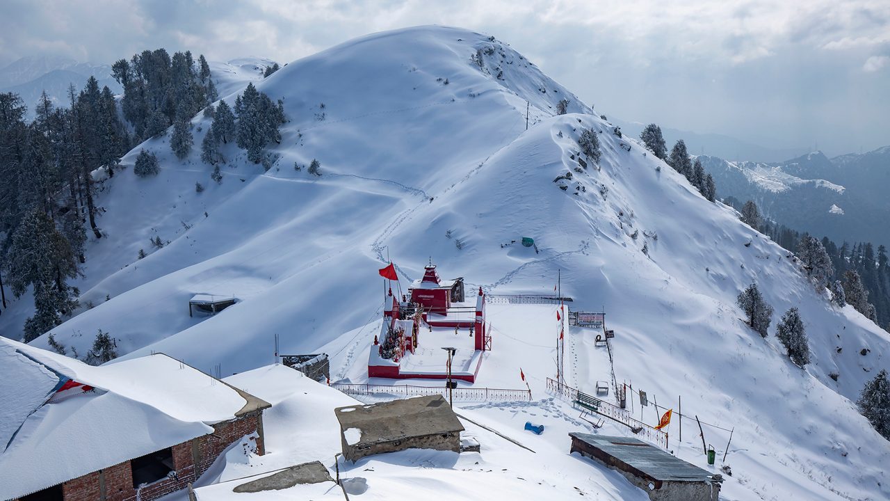
2️⃣ Dainkund Peak
The Singing Hill & Strategic Himalayan Summit


SEO Keywords: Dainkund Peak height, Singing Hill Dalhousie, highest peak in Dalhousie, Dainkund trek, Dalhousie viewpoints
At 2,755 meters (9,039 feet), Dainkund is the highest peak in Dalhousie.
🌄 Panoramic Views Include:
- Dhauladhar range
- Pir Panjal range
- Ravi River valley
- Chenab River basin
- Beas River flow
- Khajjiar meadow region
🎶 Acoustic Geography – Why It’s Called “Singing Hill”
High-velocity alpine winds passing through:
- Deodar forests
- Oak groves
- Pine slopes
create a whistling resonance effect along the ridge.
This natural wind acoustics phenomenon gives Dainkund the nickname:
“Singing Hill of Himachal.”
Local mythology associates the name Dain-kund (witch pond) with ancient folklore of malevolent spirits defeated by divine intervention.
🛡 Strategic Significance – Indian Air Force Presence
Since 1971, the
Indian Air Force
has operated a radar station near the summit.
Important Travel Advisory:
- Civilian vehicles stop at Lakkarmandi barrier
- 3 km trek required to summit
- Photography of radar installations strictly prohibited
- Drone flying restricted
This makes Dainkund not just scenic — but strategically vital.
3️⃣ Maa Pohlani Devi Temple
High-Altitude Spiritual Geometry of the Himalayas


SEO Keywords: Maa Pohlani Devi Temple trek, Dainkund temple, Kali temple Dalhousie, Pohlani Mata Darshan
Situated at the ridge’s highest sacred point, the temple is dedicated to an incarnation of Goddess Kali.
Architectural Uniqueness:
- Open-air structure
- Roofless shrine
- Sky as canopy
- No anthropomorphic idol
- Represented by a Trishul (trident)
This style resembles high-altitude Himalayan shrines like
Shikari Devi Temple.
🛕 Spiritual Narrative
Legend holds that the Goddess manifested from stone here to defeat witches residing on the peak.
Temple Details:
| Detail | Specification |
|---|---|
| Deity | Pohlani Mata (Kali form) |
| Iconography | Trishul |
| Architecture | Roofless shrine |
| Timings | 6 AM – 6 PM |
| Distance from Dalhousie | 8–12 km |
On clear days, devotees may glimpse Manimahesh Kailash peak — a sacred Himalayan sight.
4️⃣ Climate & Best Time to Visit Dalhousie
SEO Keywords: Dalhousie weather, best time to visit Dalhousie, Dainkund snowfall, Panchpula monsoon
| Season | Temperature Range | Highlights |
|---|---|---|
| Summer (Apr–Jun) | 10°C–25°C | Best visibility, peak season |
| Monsoon (Jul–Sep) | Heavy rain (150–170mm/month) | Lush greenery, strong waterfalls |
| Autumn (Oct–Nov) | Clear skies | Crisp air, ideal trekking |
| Winter (Dec–Mar) | Down to -23°C at higher altitude | Snow at Dainkund |
Winter Note: Black ice common; carry thermal layers & snow boots.
5️⃣ Connectivity & Transport Guide (2025/26 Estimates)
SEO Keywords: How to reach Dalhousie, Pathankot to Dalhousie taxi, Dalhousie sightseeing cab fare
Nearest Transit Hub:
Pathankot
- Railway Station: ~80 km
- Road Time: 2–3 hours
- Taxi Fare: ₹2800–₹3300
Local Travel:
| Route | Approx Fare (INR) | Duration |
|---|---|---|
| Dalhousie → Panchpula | 150–400 | 15 min |
| Dalhousie → Lakkarmandi | 800–1200 | 30 min |
| Full Day Cab | 2000–3500 | 8 hrs |
Public buses by HRTC available from Chandigarh & Dharamshala.
6️⃣ Trekking Ecosystem Around Dainkund
🏔 Ganji Pahari Trek
Ganji Pahari
Altitude: 2,745 meters
Distance: 3.5 km from Panchpula
Difficulty: Moderate
Known as “Bald Hill” due to vegetation absence at summit.
Perfect for:
- Sunset views
- Stargazing
- Camping
🥾 Dainkund Ridge Walk
Starting Point: Lakkarmandi
Distance: 3.5–5 km one way
Difficulty: Easy to Moderate
Continuation possible toward Jot Pass (2,772m) for experienced trekkers.
7️⃣ Gastronomy & Mud House Café Culture
SEO Keywords: Dalhousie cafes, Mud House cafe Dalhousie, food near Panchpula
Emerging “Mud House” cafés emphasize:
- Clay architecture
- Wooden interiors
- Rustic Himalayan ambience
Popular Items:
- Thentuk
- Thukpa
- Momos
- Israeli cuisine
- Maggi & Bhutta near waterfall stalls
These spaces blend slow travel culture with mountain simplicity.
8️⃣ Practical Travel Insights
✔ Mobile network weak at Dainkund
✔ Download offline maps
✔ Respect temple sanctity
✔ Avoid loud music near shrine
✔ Ask before carrying leather items inside temple
✔ Ziplining at Panchpula: ~₹200
🌄 Final Synthesis: The Dalhousie High-Altitude Circuit
The Panchpula–Dainkund–Pohlani Devi triad represents:
- Hydrological identity
- Revolutionary heritage
- Acoustic geography
- Strategic military importance
- Spiritual devotion
- Eco-tourism potential
It is not merely a sightseeing route. It is a multi-layered Himalayan experience. This experience blends patriotism, mythology, climate science, and sustainable tourism.
Dalhousie is transitioning toward eco-conscious tourism. Preserving its fragile ecology is a shared responsibility. Cultural authenticity also remains a joint duty between travelers and locals alike.
Leave a Reply